Arrival to Káthmándú
It was a really crazy travel to Káthmándú. Bus Brno-Vienna, plane Vienna-Düsseldorf, plane Düsseldorf-Abú Dhabí, plane Abú Dhabí-Káthmándú.
The first administrative operations waited for me right at the airport. Well... I had enough money for the visa, but it took some time to find some extra photos.
What you will need to manage before your outdoor experience?
- To pay for the Nepal Visa – 40 USD (at the airport in USD currency)
- Trekking permit (TIMS card) – 20 USD (at Nepal Tourism Board in NPR - they do not accept USD). Change your money at the bank (opening time os 10:00 am). You can use ATM (both VISA and Master Card)
- National park fee – 20 USD (at Nepal Tourism Board in NPR)
TIMS card and National park fee you will pay at this place: Nepal Tourism Board, Pradarshani Marg, Kathmandu 44617, Nepal. Do not forget to have a lot of passport photos, at least 8, they want it everywhere (Visa, TIMS, local SIM Card, every permit…).
More information about Annapurna entry permits. I was happy, because after arrival my friend Sonam Sherpa (Sherpa Adventure Travels - Nepal travel operator) provided me with his car and his personal driver and he got me everywhere I needed.
He did this as a personal favour to me and I was very grateful for all the help he extended to me.
It is easy to find the Nepal Tourism Board office. Next time, during my Everest Base Camp trek experience I managed all administrative operations on my own.
How not to get crazy in Káthmándú
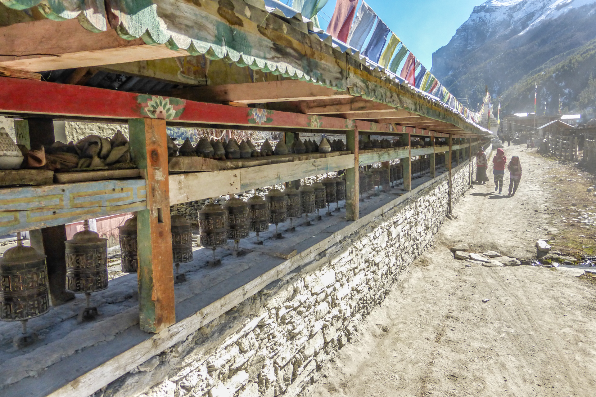
Káthmándú is a crazy city, it is classical Asian place: thousands of people, thousands of streets, thousands of shops. There are several items you have to do to survive.
- Transports - from airport to the hotel by taxi (500-600 NPR) or make a deal with your hotel manager, he can offer you a pick-up service for free. For sight-seeing you do not need any vehicle, you can do it on foot. For transport to the mountains you can use air - plane or bus. The Káthmándú bus station is a crazy place. There are hundreds of buses and nobody knows where they are going to. Ask your taxi driver for help to find the right one or negotiate the transport with the hotel manager, he will help you.
- Where to sleep - travelers usually sleep in Thamel (most crazy district full of travelers and shopping centers). I can recommend Karma Travelers Home (Hotel Karma), but there are many other hotels. If you prefer to have some privacy, try to find a hotel in another district.
- Where and when to exchange money - banks open at 10am, you can exchange both USD and EUR currency. For a 3-week trip you will need around 70 000 NPR. Banks are everywhere (for example one of them is in front the Karma hotel).
- Connectivity - Annapurna circuit is quite well covered by mobile signal (Tilicho lake part with different operator than other parts). Buy a SIM card (data and voice services) with the local number (1500-3000 NPR). Anyway there are places that are not covered. If you want to have 100% connectivity use the Iridium satellite phone, I had one with me and it worked well. Globalstar Spot device is quite useless in this case as it does not work there.
- Shopping - Káthmándú is the the biggest outdoor shopping park on planet Earth. Buy only what you're actually missing for your trek - sleeping bag, goose down jacket, hat. You can go on a shopping spree once you've descended from the mountains.
- GPS - in Káthmándú every street looks the same, if you don´t want to get lost use a GPS device. Make your hotel place a point of interest. Generally... I used GPS device more in KTM than on the trek. Garmin devices are a good choice.
- Photos - you will need passport photos for every permit, for every document, almost everywhere. Take at least eight passport photos with you.
Equipment and planning of the trek
- Essential outdoor gear. You do not need a tent and cooking stuff because you can use guest house services.
- Planning of the Annapurna trek - software and tools.
- Maps - You can buy a laminated Terra Quest Annapurna circuit map (sometimes does not fit and too big scale), you can buy great local maps in KTM in every store (400 NPR), you can use commercial GPS Himalayas map for your Garmin device, or you can use free GPS maps (the Open MTB is quite good). You can follow someone's steps by Wikiloc off-line maps for cell phone or you can plan your trek on-line a use Alpenvereinaktiv.com off-line maps for Annapurna region (you have to plane it on your own, or upload some recorded treks from Wikiloc).
- Insurance - I am member of Alpenverein and this membership includes the worldwide insurance up to 6000 m. Anyway before a trip like this I usually buy an insurance extension - expedition insurance Alpenverein Premium.
On the road
- Prices - ask about the price (transport, guest house, souvenirs) in advance and negotiate.
- Lonely hero - if you travel alone, do not tell everybody that you are alone.
- Friends - make friends. There are many travellers on the road and they can help you.
- Health - take your first aid kit with you (pills, drugs and ointments).
- Acute Mountain Sickness - do not take pills against the AMS (Acute Mountain Sickness) when the first headache comes – follow the acclimatization rules and go down. I started to feel it in Humde for the first time.
- Toiletries - take toilet paper and wet tissues with you - you will appreciate it, trust me.
- Water purification pills - you won't need it. Drinking water is OK there.
Annapurna Circuit schedule
Day no. 1 - Káthmándú - Besi Sahar - Ngadi
Buses leave the bus station early in the morning, so ask your taxi driver to help find the right bus; the bus station is a crazy place. Buy your bus ticket in advance (you can usually buy a voucher at the hotel).
The drive takes around 7 hours, there are many breaks at places with refreshment (usually fried "something"). Besi Sahar is not a very nice village. It is a village below the mountains full of people that live off of travelers.
They offer many services (food, bed, transport) and they negotiate quite aggressively. I did not talk to anybody and I followed the mark towards the mountains.
But this part of path was not nice at all: because of Chinese hydropower construction there were a lot of trucks. During the trek some guys picked me up and took me to Ngadi to the first camp in the village.
Links and downloads:
Day no. 2 - Ngadi - Tal
Next day I continued on the road. I visited Ngadi (hydropower like in action movie), Bahundanda (police check point), Ghermu, Syange, Chamje (police check point again) and finally Tal.
If I wanted to visit this area again, I would take a car at least to Syange, because this trek was definitely not such a breath-taking experience. Tal is a nice village.
There is a waterfall behind it, I was sleeping in the first guest house by the road, just behind the "football field". The old woman did not know English and she cooked only two kinds of food, but it was a nice place.
All communication was mediated by a little 10-year old girl. This day was long trek and I was completely exhausted.
Links and downloads:
Day no. 3 - Tal - Chame
Next day I followed across Dharapani (check point), Bagarchap and the Timang settlement. Timang is a fantastic place at the top of the hill (2600m), there are direct views of the Manaslu mountain (8156m).
It is a good place to sleep, unfortunately I got there around noon so I made a decision to continue. Just before sunset I got to Chame, or rather the suburb of Chame.
There were no free beds at the guest-house I wanted to sleep, but an old woman offered me to sleep in her chapel. It was a great experience, I was sleeping with gods.
Links and downloads:
Day no. 4 - Chame - Humde
I continued to Pisang in the morning, it is a place of pilgrimage - especially the Upper Pisang. Travelers usually stay there for a day. Unfortunately I missed the turning to Upper Pisang, so I followed the path to the Humde.
This part of trek was beautiful. This village was almost empty because most of travelers sleep in Pisang and next day in Manang. Humde is a village in the middle (There are several names in maps: Humde, Hunde, Hongde - all are correct).
It was a very cold place, the entire evening I spent in the kitchen where the cook prepared food for me. It was a great evening, I spent it in conversation with natives.
Links and downloads:
Day no. 5 - Humde - Manang
I felt sick the next day and despite that I continued to Manang. It took me a few hours. I choose the Hotel Yeti, but I did not feel comfortable there, because it was a very commercial guest-house.
The night before was much better. Anyway...I had a headache, I had a cold - AMS started but I did not want to believe that it was that. I stayed the whole day in my sleeping bag and tried to sleep - it was a mistake.
Other travelers tried to get acclimatized by a trip to the waterfall, but not me. I thought that was getting acclimatized by sleeping - it was a big mistake.
Links and downloads:
Day no. 6 - Manang - Tilicho Base Camp
Despite the fact that I still felt sick, I went to Tilicho Base Camp next day. It was one of the best treks I have ever done. Fantastic views, no people, clear path and great weather. But this trek is not easy.
You have to overcome a lot of elevation gain (from 3400m to 4200m) and due to my actual physical condition it took me around 7 hours (people usually do it in 5 hours).
There are two guest-houses in the middle of the trek. The last part of the trek is a little bit dangerous because of landslide areas (over one hour). A helmet would be good at this place. After that I arrived to the Tilicho Base Camp.
There are several guest-houses, I chose the first one with the little square in the middle. It was an extremely cold place - both outside and inside the dormitory room.
Links and downloads:
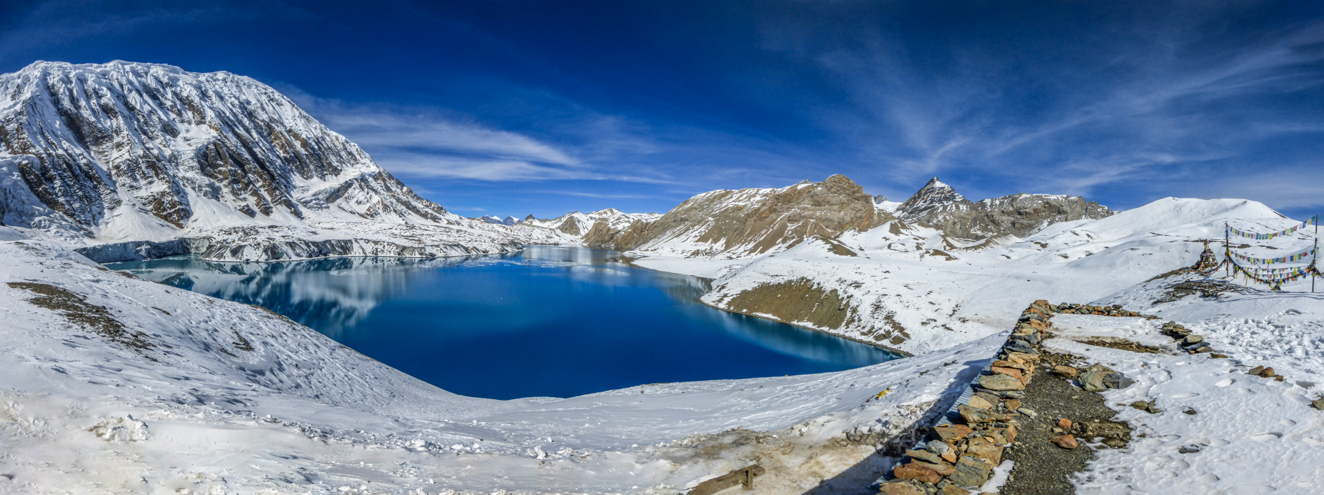
Day no. 7 - Tilicho Base Camp - Tilicho lake - Tilicho Base Camp
It was -20°C that night and everyone was completely frozen the next morning, we had to ask people in the kitchen for running water, because outside there was only ice. That day I had to overcome 800m to get to the highest placed lake in the whole world - Tilicho lake.
Surprisingly the most dangerous part was the first part - because of the icy path in the steep side of the hill. Higher the altitude started to play with my body a very cruel game and I got to the Tilicho lake exhausted. But it was worth it.
Tilicho lake is an amazing place, definitely a "must-see"! I was surprised that there was a tea shop - but later I found out that tea shops are everywhere in Nepal. Then I came back to the Base Camp.
Some people continued back to Manang or Yak Kharka, I stayed in the camp for one more night. Later I heard that some people got to the lake so late that they had to sleep there (in the tea shop).
Links and downloads:
- Map of Tilicho Base Camp - Tilicho Lake - Tilicho Base Camp trek
- GPS (GPX) coordinates of Tilicho Base Camp - Tilicho Lake - Tilicho Base Camp trek
Day no. 8 - Tilicho Base Camp - Yak Kharka
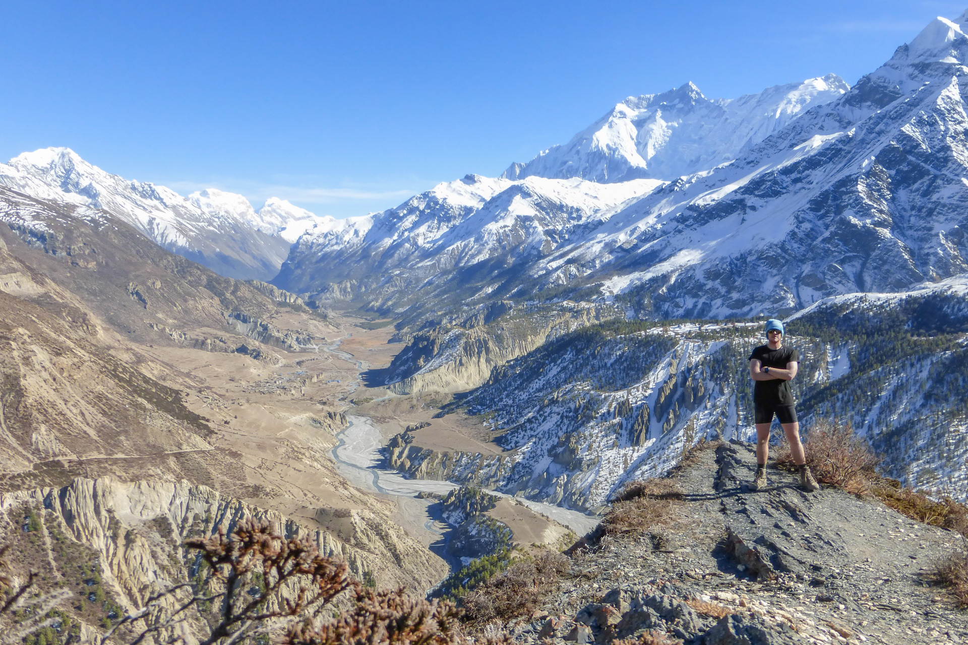
I felt really sick the next day - headache, cold, neck pain, no strength - anyway, I made the decision to continue to the Yak Kharka. It was a fantastic trip, I have to say that it was the best trek of the Annapurna Circuit.
I followed the Yak Kharka shortcut up to the horizon, there were herds of yaks and the best views I have ever seen. The cover picture of this post is from the highest point of this trek. You can watch whole Manang valley behind me on this picture.
I stayed at this place for almost two hours just watching everything all around. It was a magical moment. Then I followed the path down to the Yak Kharka - it was the most dangerous place because the whole day it was in the shadow of the mountain so it was icy and really steep - and I was alone.
The way down took me 2 hours, then I crossed the river over the bridge and the rest of way to the Yak Kharka took me around an hour and half. I got there 5 minutes before dark.
Links and downloads:
- Map of Tilicho Base Camp - Upper Khangsar - Yak Kharka
- GPS (GPX) coordinates of Tilicho Base Camp - Upper Khangsar - Yak Kharka
Day no. 9 - Yak Kharka - Thorong Phedi - High Camp
I do not remember much of trek from Yak Kharka to the High camp - only that there were some parts with landslide areas. When I arrived to the Thorong Phedi I met all my Polish, Russian and American friends from previous guest-houses.
All of them continued to the High camp and so did I. Before that I took pictures with a baby-yak and "Bob Marley-like" Nepal guy. High cam was a guest-house complex for at least one or two hundred people. I got there as the last one, the AMS was worse and worse. I took some pills and vitamins and went to bed.
Links and downloads:
- Map of Yak Kharka - Thorong Phedi - High Camp
- GPS (GPX) coordinates of Yak Kharka - Thorong Phedi - High Camp
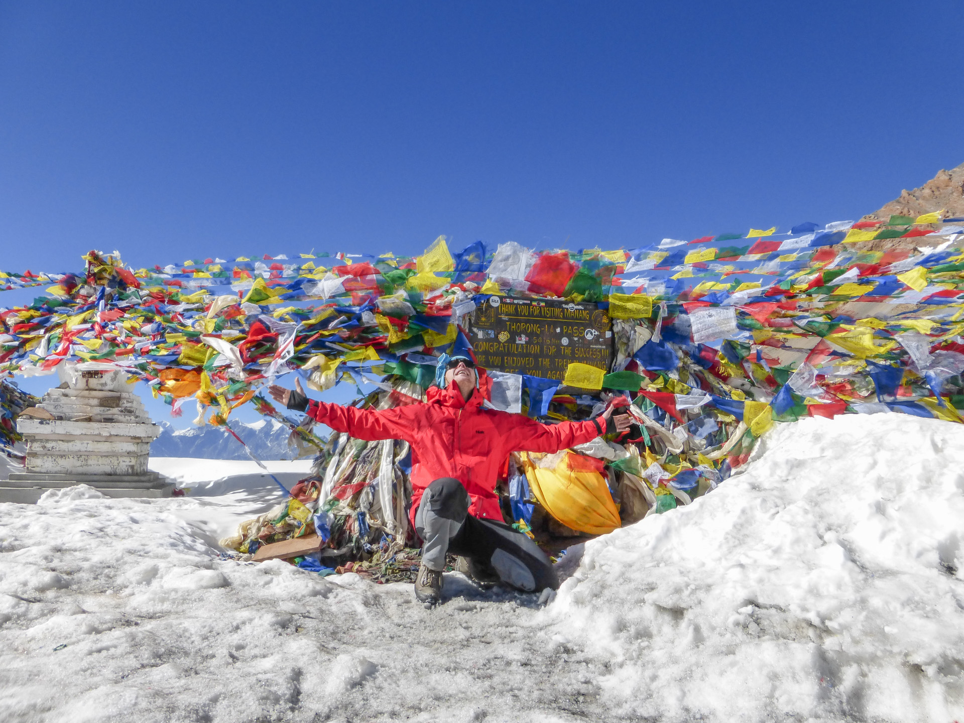
Day no. 10 - High Camp - Thorong La - night in tent
Everybody in the High camp set out at 4am or 5am next day. They wanted to see the sunrise from the Thorong La pass. But not me. My sickness escalated so I made the decision to stay in camp and to take a day off. After the sunrise I got better so I changed my decision. I set out as the last one from the camp.
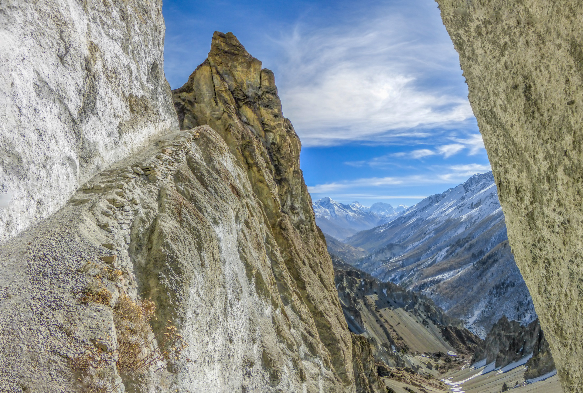
The way was completely covered with snow, but the path was quite visible. Anyway all the treks were previously recorded on my GPS device. About one kilometer before the pass I was thinking that I was dying. I had never been so high, it was a new experience for me. My body was so weak.
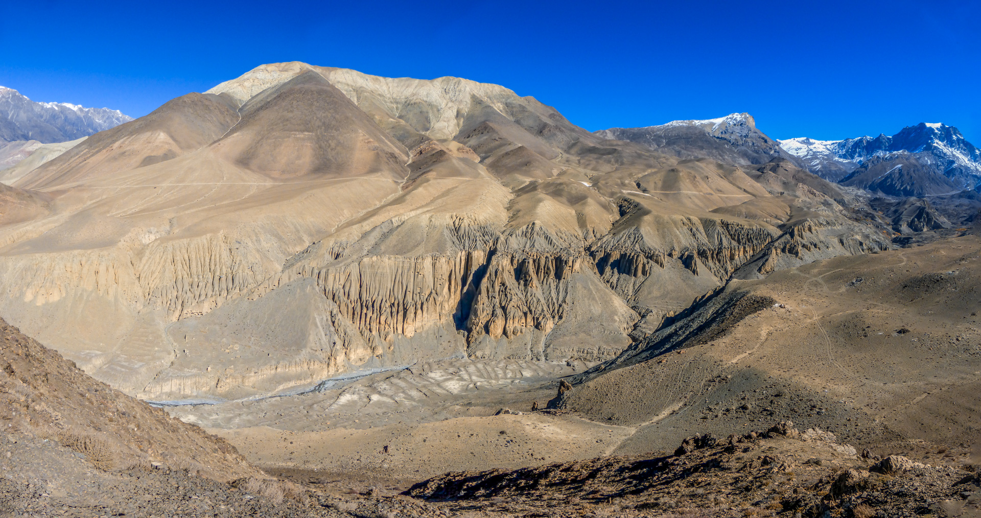
Finally I reached the Thorong La pass (5416m). There was a tea shop - naturally - so I took one cup of masala tea and pointed down to the Muktinath the famous spiritual town. But it was quite late and I was exhausted. In the middle of the steep hill there was a place flat enough for camping.
A few people who went opposite direction were already camping there. I got an idea - because I had a tent with me, cooking stuff and quite a lot of food (altogether 6kg more then other travelers) - to sleep in the wild nature without the guest-house support, but with the view to the Upper Mustang district. It was a test of my outdoor gear.
Links and downloads:
- Map of High Camp - Thorong La - camping place behind the Thorong La trek
- GPS (GPX) coordinates of High Camp - Thorong La - camping place behind the Thorong La trek
- I am not completely sure about the final point of the trek (I lost the exact POI coordinates). It was the only flat place in the steep hill, where it was possible to put down a tent. You will recognize this place when you see it, it's the only one.
Day no. 11 - Muktinath - day off
It was a very cold night. It was -8°C in the tent and at least -20°C outside. Early in the morning I packed up everything immediately and I was "running" to the Muktinath. I got there in next 3 hours, I bought a room in the guest-house in the middle of the town and I fell asleep.
Links and downloads:
- Map of camping place behind the Thorong La - Muktinath trek
- GPS (GPX) coordinates of camping place behind the Thorong La - Muktinath trek
Day no. 12 - Muktinath - Jomsom
Next day I continued to the Jomsom. I chose the left side (direct) of the path so I followed the road for cars, but with the great views to the Upper Mustang mountains. Some of my friends chose the right side (the longer one) so they visited a lot of smaller villages and monasteries.
All of us enjoyed the majestic view of Dhaulagiri (8167m). It was an extremely windy part of the trek. I arrived to Jomsom late in the afternoon and I was thinking about what to do with the rest of my day. I have seen enough of mountains and there was a road full of jeeps and buses in front of me.
I lost motivation to continue on circuit. In the evening - during the dinner - I heard some Australian girl talking about the elephants and the Chitwan national park. It seemed like a good idea so I bought flight tickets to Pokhara for next morning (yes... there is an airport in Jomsom), I paid 110 USD at the Nepal Airlines kiosk. Then I went to sleep in the guest-house near the airport.
Day no. 13 - Jomsom - Pokhara
Next day all travelers waited in front of main airport building at 5:30 am. Unfortunately the first airplane left at 8:30. Flight took about 30-40 min. When we arrived to Pokhara the climate was very different. It was a very sunny hot day.
I shared taxi with some german married couple and we found some hostel near the Pokhara lake-side (1000 NPR/night and breakfast). I did not enjoy the Pokhara area because it was over-crowded and it looked like some shopping center.
So the next day I bought a bus ticket (bus voucher at the guest-house - 550 NPR) for 6:00 am left directly for Chitwan.
Day no. 14 - Drive to Chitwan - Sauraha - Elephant Breeding Center
The drive took about 7 hours, we arrived to the bus station (parking place among dirty fields - nothing romantic). Forty taxi drivers had already waited for travelers, some of them were paid by hotel and resorts.
I chose one of them, so this transport was for free. I chose the Travellers Jungle Camp resort because it was written about in the Lonely Planet Guide: they have their own elephant - well ...it is not true any more. But the accommodation was OK.
Day no. 15 -Safari
The owner helped with my program - he recommended to visit the Elephant Breeding Center and he sold me a Safari program for the next day. Tthe safari was long, boring and we saw only a few animals (a crocodile farm and the ass of a rhino).
Resorts in Sauraha are nice but everything around is dirty, full of garbage and nobody cares about it. I could not believe that I was in a National Park. Well… I definitely recommend the Himalayas rather than this southern part of Nepal.
Day no. 16 - Drive to Káthmándú
Next day I came back to Káthmándú. The drive took several hours again so I took a break in the hotel for the rest of day. I slept in the Karma Travelers Home again.
Day no. 17 - Káthmándú - Day off and leaving home
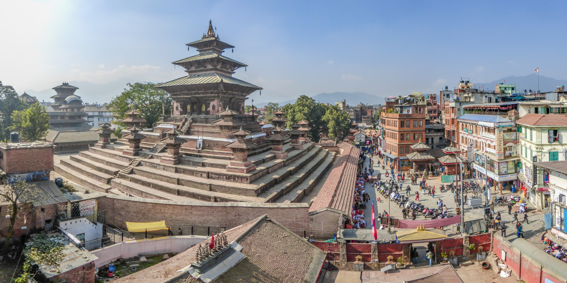
This day was a shopping day. Hats, socks, scarfs, goose down jackets and vests - negotiation, negotiation and negotiation. I Visited the Durbar square as well. These days it was untouched by earthquake and it was full of pyramids.
I visited the old kings palace as well. I was really lucky, that I made the decision to visit it. A lot of this Nepal heritage is lost today.
Early in the morning I left Nepal. It was great experience, I can recommend this trip.